
The UK is bracing for a major weather event. Storm Benjamin is forecast to bring heavy rain and strong winds across large parts of England and Wales. The warnings are already in place. Citizens and local authorities are being urged to prepare now.
According to the Met Office, the storm’s effects will begin late Wednesday and extend into Thursday. A yellow weather warning for rain covers southern and eastern England until 9 pm Thursday.A separate wind warning is active from early Thursday morning in eastern England, and from early Thursday in southwest England and western Wales.
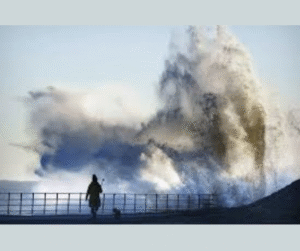
Forecasts show wind gusts of up to 70 mph in some coastal areas. In addition, rainfall totals up to 50 mm or more are expected in affected regions by early Thursday morning.
What to Expect
-
Roads may flood quickly. Travel times will increase.
-
Train and bus services may be disrupted or suspended.
-
Power cuts become more likely when gusts reach exposed areas.
-
Coastal locations may face large waves and blown-debris hazards.
Deputy Chief Meteorologist Dan Harris warned that the exact track and intensity of Storm Benjamin remain uncertain. He stressed that the public should monitor updates and adapt as conditions evolve.
Where and When the Impact Will Hit
The earliest onset of heavy rain is expected from Wednesday evening. For London, the storm is likely to arrive in full force on Thursday, with winds gradually rising to around 40 mph by late afternoon. Yorkshire, eastern England and coastal zones are already under wind and rain warnings.
Why You Should Take It Seriously
Storm Benjamin wasn’t given an official name initially by the Met Office, but it was named by Météo‑France and is already causing concern because of its low-pressure system and the rich moisture it carries. The combination of strong wind, heavy rain and uncertain path means that even areas not normally at risk could face problems. The fact that forecasters flagged a “greater than usual uncertainty” underscores that the situation may change quickly.
Tips for Staying Safe
-
Avoid travel if possible during the hours of peak impact.
-
Park vehicles away from trees or weak structures that could collapse or be blown over.
-
Keep an emergency kit ready with a torch, batteries and a charged mobile phone.
-
Stay away from flooded roads — just 6 inches of fast-moving water can knock you off your feet, and a foot of water can float a vehicle.
-
Listen to your local authority’s updates and the Met Office alerts.
The Bigger Picture
Storm Benjamin adds to the growing trend of volatile weather across the UK and Europe.Climate scientists say that warming seas and shifting weather patterns help fuel storms like this. While no single storm can be directly linked to climate change, the broader frequency and intensity of storms are consistent with predictions. Taking this into account, planning and infrastructure resilience become even more critical.
The warned regions
If you are in the warned regions, treat Storm Benjamin with respect. Don’t wait until conditions worsen. Prepare now. Drivers, travellers, and residents — exercise caution. When the rain and wind gusts hit, the effects can escalate quickly. Keeping informed, staying clear of danger zones and following official advice will reduce the risk significantly.
Storm Benjamin may be labeled a “yellow” warning, but its potential for disruption is real. Simple preparation, vigilance and knowing what to do can make all the difference.