
Tropical Storm Lorena: Path, Impact, and Latest Updates
Introduction
Tropical Storm Lorena has formed in the Pacific Ocean, raising concerns for communities in its path. The storm is gaining strength, and weather experts are closely monitoring its movement. Residents in coastal areas are being urged to stay alert as conditions may change quickly.
What We Know About Tropical Storm Lorena
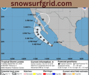
Tropical Storm Lorena developed over warm waters in the eastern Pacific. The National Hurricane Center (NHC) reported that the system has strong winds and heavy rainfall. Forecasters say the storm could bring dangerous conditions to Mexico’s Pacific coastline.
The storm’s maximum sustained winds are near 45 mph, with higher gusts recorded. Meteorologists expect Lorena to strengthen as it moves west-northwest. Rainfall amounts may range between 4 to 8 inches in some regions, which could trigger flash floods and mudslides.
Areas at Risk
Coastal towns in western Mexico are most at risk from Lorena. Baja California Sur and nearby regions are watching the storm closely. Fishermen, travelers, and residents in low-lying zones have been advised to prepare emergency plans.
Ports in certain areas may close due to rough seas. Strong winds can knock down trees and power lines. Heavy rain could impact road travel and isolate smaller communities.
 Safety Measures in Place
Authorities in Mexico have already issued tropical storm warnings for vulnerable areas. Local officials are urging residents to secure their homes and avoid risky areas. Emergency shelters are being prepared for families living near the coast.
The Red Cross and disaster management teams are on standby. Supplies such as food, water, and medical aid are being distributed to areas that may be cut off. People are encouraged to follow updates from official weather agencies rather than social media rumors.
Travel Concerns
Tourists in popular beach destinations should remain cautious. Airlines may adjust flight schedules depending on the storm’s intensity. Travelers should stay in touch with their hotels and airlines for updated information.
Cruise ships may also change routes to avoid Lorena. Coastal activities like surfing, boating, and swimming are not safe until the storm passes.
Potential Development
Meteorologists are tracking whether Lorena could strengthen into a hurricane. Warm ocean waters provide the energy needed for storms to grow. However, wind patterns will determine how fast Lorena develops.
Even if the storm does not become a hurricane, heavy rains remain a major concern. Flash floods and landslides are dangerous, especially in mountainous regions.
How Residents Can Stay Safe
People living in Lorena’s path should take simple but vital steps to stay safe:
-
Keep emergency supplies ready, including food, water, and batteries.
-
Stay informed by listening to weather bulletins from trusted sources.
-
Avoid rivers, streams, and flood-prone areas during heavy rain.
-
Follow evacuation orders if issued by local authorities.
Preparedness is key in reducing storm-related risks.